Categorieën
Veilig online betalen
Betaal veilig via uw eigen bankomgeving
Winkelwagen
Geen items in winkelwagen
Ga naar winkelwagen
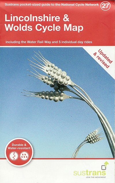
Fietskaart 27 Cycle Map Lincolnshire and Wolds | Sustrans (9781914410079)
- ISBN / CODE: 9781914410079
- Editie: meest recente versie
- Schaal: 1:110000
- Uitgever: Sustrans
- Soort: Fietskaart
- Serie: Cycle Map
- Taal: Engels
- Uitvoering: Scheur- en watervast
- Bindwijze: -
- Schrijf als eerste een review
-
€ 12,95
Uitverkocht, nooit meer leverbaar

-
Overzichtskaart Fietskaarten 1:110.000 Engeland, Wales, Schotland en Noord-Ierland | Sustrans
.jpg)
Producten op deze overzichtskaart:
Klik op een product om naar de pagina van dat product te gaan.
Overzichtskaarten
Beschrijving
incolnshire's gentle countryside, quiet lanes, network of waterways and market towns make it a rewarding place to cycle. Whether touring the county or looking for a flat family ride, there are numerous great routes to explore.
This revised map is in the series of pocket sized, folded maps to the National Cycle Network which include clearly mapped on-road and traffic-free paths, easy to read contours and detailed town insets. The series is published by CycleCity Guides in partnership with Sustrans. 1:110,000 scale; folded 155mm x 99mm; flat 792mm x 630mm.
The Lincolnshire & Wolds Cycle Map includes the Water Rail Way and 5 individual day rides and is now printed on waterproof paper.
Major routes covered on this map:
National Route 1 between Woodhall Spa and just south of the River Humber via Bardney, Lincoln & Market Rasen. This route includes the traffic-free Water Railway Path between Woodhall Spa and Lincoln.
National Route 64 between Newark-upon-Trent and Harby.
National Route 647 between Tuxford and Lincoln.
Reviews
Geen reviews gevonden voor dit product.
Schrijf een review
Graag horen wij wat u van dit artikel vindt. Vindt u het goed, leuk, mooi, slecht, lelijk, onbruikbaar of erg handig: schrijf gerust alles op! Het is niet alleen leuk om te doen maar u informeert andere klanten er ook nog mee!
Alle gerelateerde rubrieken >
Ook interessant voor europa/engeland/overig-noord-2


