Categorieën
-
Boeken
- Aanwijswoordenboeken
- Accommodatiegidsen
- Atlassen
- Bed and Breakfast Gidsen
- Bergsporthandboeken
- Campergidsen
- Camperhandboeken
- Campinggidsen
- Duikgidsen
- Fietsatlassen
- Fietsgidsen
- Fotoboeken
- Historische Atlassen
- Kanogidsen
- Kinderatlassen
- Kinderreisgidsen
- Kleurboeken
- Klimgids - Klettersteiggidsen
- Klimgids - Klimtopo
- Kookboeken
- Mountainbikegidsen
- Natuurgidsen
- Pelgrimsroutes
- Reisboeken
- Reisdagboeken
- Reisfotografiegidsen
- Reisgidsen
- Reishandboeken
- Reisinspiratieboeken
- Reisverhalen
- Sneeuwschoenwandelgidsen
- Survivalgidsen
- Tourskigidsen
- Treinreisgidsen
- Vaargidsen
- Vogelgidsen
-
Wandelgidsen
- Afrika
- Azië
-
Europa
- Albanië
- Andorra
- Armenië
- België
- Bosnië - Hercegovina
- Bulgarije
- Cyprus
- Denemarken
- Duitsland
-
Engeland
- Noord Engeland
- North East England
- ♦ Northumberland National Park
- Yorkshire and the Humber
- ♦ Yorkshire Dales Nationaal Park
- ♦ North York Moors Nationaal Park
- ■ York
- North West England
- ♦ Cumbria
- ♦ Isle of Man
- ♦ Lake District Nationaal Park
- ♦ North Pennines AONB
- ■ Liverpool
- ■ Manchester
- 🥾 Hadrian's Wall Path
- East Midlands
- West Midlands
- ♦ Peak District Nationaal Park
- ■ Birmingham
- Wales
- Swansea and the Gower
- ♦ Pembrokeshire Coast National Park
- ♦ Snowdonia Nationaal Park
- ♦ Brecon Beacons Nationaal Park
- East of England - East Anglia
- ♦ The Broads National Park
- South West England
- Cornwall
- Devon
- Dorset
- ■ Bath
- ♦ Cotswolds AONB
- ♦ Devon - Cornwall
- 🥾 South West Coast Path
- ♦ New Forrest National Park
- ♦ Exmoor National Park
- ♦ Dartmoor National Park
- ■ Bristol
- South East England
- ♦ Kent
- ♦ South Downs Nationaal Park
- ♦ Isle of Wight
- ■ Londen
- ■ Oxford
- Kanaaleilanden
- ♦ Guernsey
- ♦ Jersey
- Meer steden
- Estland
- Faroer
- Finland
- Frankrijk
- Georgië
- Griekenland
- Groenland
- Hongarije
- IJsland
- Ierland
- Italië
- Kosovo
- Kroatië
- Letland
- Liechtenstein
- Litouwen
- Luxemburg
- Malta
- Montenegro
- Nederland
- Noord-Ierland
- Noord-Macedonië
- Noorwegen
- Oostenrijk
- Polen
- Portugal
- Roemenië
- Scandinavië
- Schotland
- Servië
- Slovenië
- Slowakije
- Spanje
- Tsjechië
- Turkije
- Zweden
- Zwitserland
- Midden-Amerika
- Midden-Oosten
- Noord-Amerika
- Oceanië
- Wereld
- Zuid-Amerika
- Watersport handboeken
- Werken en wonen in buitenland
- Woordenboeken & Taalgidsen
- Kaarten
- Opruiming
- Puzzels
- Travel Gadgets
- Wandkaarten
- Wereldbollen
Veilig online betalen
Betaal veilig via uw eigen bankomgeving
- U bent hier:
- Home
- Europa
- Engeland
- West Midlands
- Boeken
- Wandelgidsen
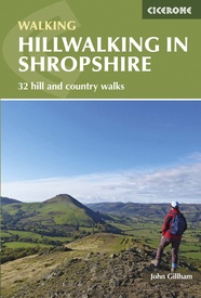
Wandelgids Hillwalking in Shropshire | Cicerone (9781852848071)
32 hill and country walks
- ISBN / CODE: 9781852848071
- Editie: 16-09-2016
- Druk: 1
- Aantal blz.: 192
- Auteur(s): John Gillham
- Uitgever: Cicerone
- Soort: Wandelgids
- Taal: Engels
- Hoogte: 17.0 cm
- Breedte: 12.0 cm
- Gewicht: 221.0 g
- Bindwijze: Paperback
- Uitvoering: -
- Schrijf als eerste een review
-
€ 17,95
Dit artikel is (tijdelijk) niet leverbaar Dit artikel is (tijdelijk) niet leverbaar
- Afbeeldingen
- Inkijkexemplaar
Beschrijving
Van de uitgever
Guidebook to 32 walking routes in Shropshire in the West Midlands. The routes range from 3 miles (5km) to 12 miles (19km), taking in highlights such as The Wrekin, Wenlock Edge, Long Mynd and Stiperstones, Castle Ring and Bury Ditches. Many routes start near delightful towns and villages including Church Stretton, Ludlow and Bishops Castle.
Seasons:
All the routes can be done in all seasons, with Autumn being best for those in woodland. August, when the heather is out, is best for Stiperstones and the Long Mynd.
Centres:
Llanymynech, Telford, Church Stretton, Craven Arms, Clun, Ludlow, Bridgnorth and Much Wenlock.
Difficulty:
Shropshire's summits are generally easy to climb. Being such a fertile county its low level paths can become overgrown in Summer. Lightweight boots are the best footwear and if you're wearing shorts, take make sure you have waterproof trousers to protect your legs from nettles and dew covered long grasses.
Must See:
The volcanic peaks of Stiperstones and Caer Caradoc, steep-sided, crag-fringed Batches of the Long Mynd, numerous Iron and Bronze Age hilltop forts, and charming little towns and villages with half-timbered buildings and fascinating historical heritage make Shropshire a hillwalkers paradise.
Reviews
Geen reviews gevonden voor dit product.
Schrijf een review
Graag horen wij wat u van dit artikel vindt. Vindt u het goed, leuk, mooi, slecht, lelijk, onbruikbaar of erg handig: schrijf gerust alles op! Het is niet alleen leuk om te doen maar u informeert andere klanten er ook nog mee!
Ook interessant voor europa/engeland/west-midlands
-

Wandelgids 032 Pathfinder Short Walk
€ 11,95Wandelgidsen West Midlands -

Wandelkaart - Topografische kaart 24
€ 19,50Topografische kaarten West Midlands -

Wandelkaart - Topografische kaart 14
€ 25,95Topografische kaarten West Midlands -

Reisgids 111 places in Places in Cov
€ 19,50Reisgidsen West Midlands -

Wandelkaart - Topografische kaart 13
€ 19,50Topografische kaarten West Midlands


