Categorieën
Veilig online betalen
Betaal veilig via uw eigen bankomgeving
Winkelwagen
Geen items in winkelwagen
Ga naar winkelwagen
Topografische kaarten - Bourgondië - Morvan
Overzichtskaarten
-
Topografische kaarten IGN 25.000 Bourgondië: ZUIDELIJK GEDEELTE

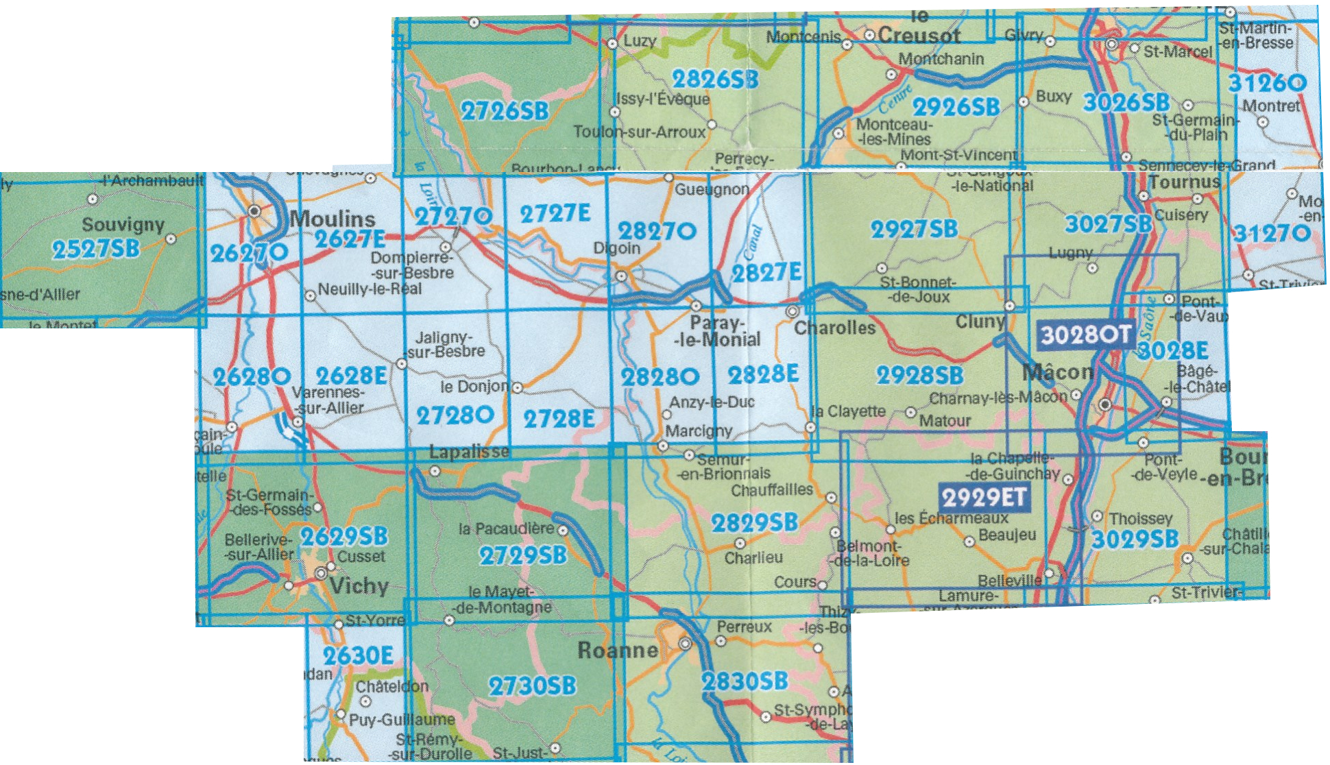
Producten op deze overzichtskaart:
Klik op een product om naar de pagina van dat product te gaan.
- Wandelkaart - Topografische kaart 2627SB Moulins | IGN - Institut Géographique National
- Wandelkaart - Topografische kaart 2628SB St-Pourçain-sur-Sioule | IGN - Institut Géographique National
- Wandelkaart - Topografische kaart 2630SB Maringues | IGN - Institut Géographique National
- Topografische kaart - Wandelkaart 2726SB Bourbon-Lancy | IGN - Institut Géographique National
- Wandelkaart - Topografische kaart 2727SB Dompierre-sur-Besbre | IGN - Institut Géographique National
- Wandelkaart - Topografische kaart 2728SB Le Donjon | IGN - Institut Géographique National
- Wandelkaart - Topografische kaart 2729SB Lapalisse | IGN - Institut Géographique National
- Wandelkaart - Topografische kaart 2730SB le Mayet-de-Montagne | IGN - Institut Géographique National
- Wandelkaart - Topografische kaart 2826SB Luzy, Toulon-sur-Arroux | IGN - Institut Géographique National
- Wandelkaart - Topografische kaart 2827SB Paray-le-Monial | IGN - Institut Géographique National
- Wandelkaart - Topografische kaart 2828SB Charolles | IGN - Institut Géographique National
- Wandelkaart - Topografische kaart 2829SB Charlieu – Chauffailles | IGN - Institut Géographique National
- Wandelkaart - Topografische kaart 2830SB Roanne – Thizy-les-Bourgs | IGN - Institut Géographique National
- Wandelkaart - Topografische kaart 2926SB Montceau-les-Mines, Ecuisses | IGN - Institut Géographique National
- Wandelkaart - Topografische kaart 2927SB St-Bonnet-de-Joux – Saint-Gengoux-le-National | IGN - Institut Géographique National
- Wandelkaart - Topografische kaart 2928SB Cluny Matour | IGN - Institut Géographique National
- Wandelkaart - Topografische kaart 2929ET Beaujeu - Belleville - Haut Beaujolais – Rhônevallei – Bourgondië | IGN - Institut Géographique National
- Wandelkaart - Topografische kaart 3026SB Chalon-sur-Saône, St-Gernain-du-Plain | IGN - Institut Géographique National
- Wandelkaart - Topografische kaart 3027SB Tournus - Lugny | IGN - Institut Géographique National
- Wandelkaart - Topografische kaart 3028OT Mâcon - Cluny | IGN - Institut Géographique National
- Wandelkaart - Topografische kaart 3029SB Châtillon-sur-Chalaronne – Belleville | IGN - Institut Géographique National
- Wandelkaart - Topografische kaart 3126SB Mervans, Montret. Louhans | IGN - Institut Géographique National
- Wandelkaart - Topografische kaart 3127SB Cuiseaux | IGN - Institut Géographique National
-
Topografische kaarten IGN 25.000 Bourgondië: OOSTELIJK GEDEELTE + MORVAN
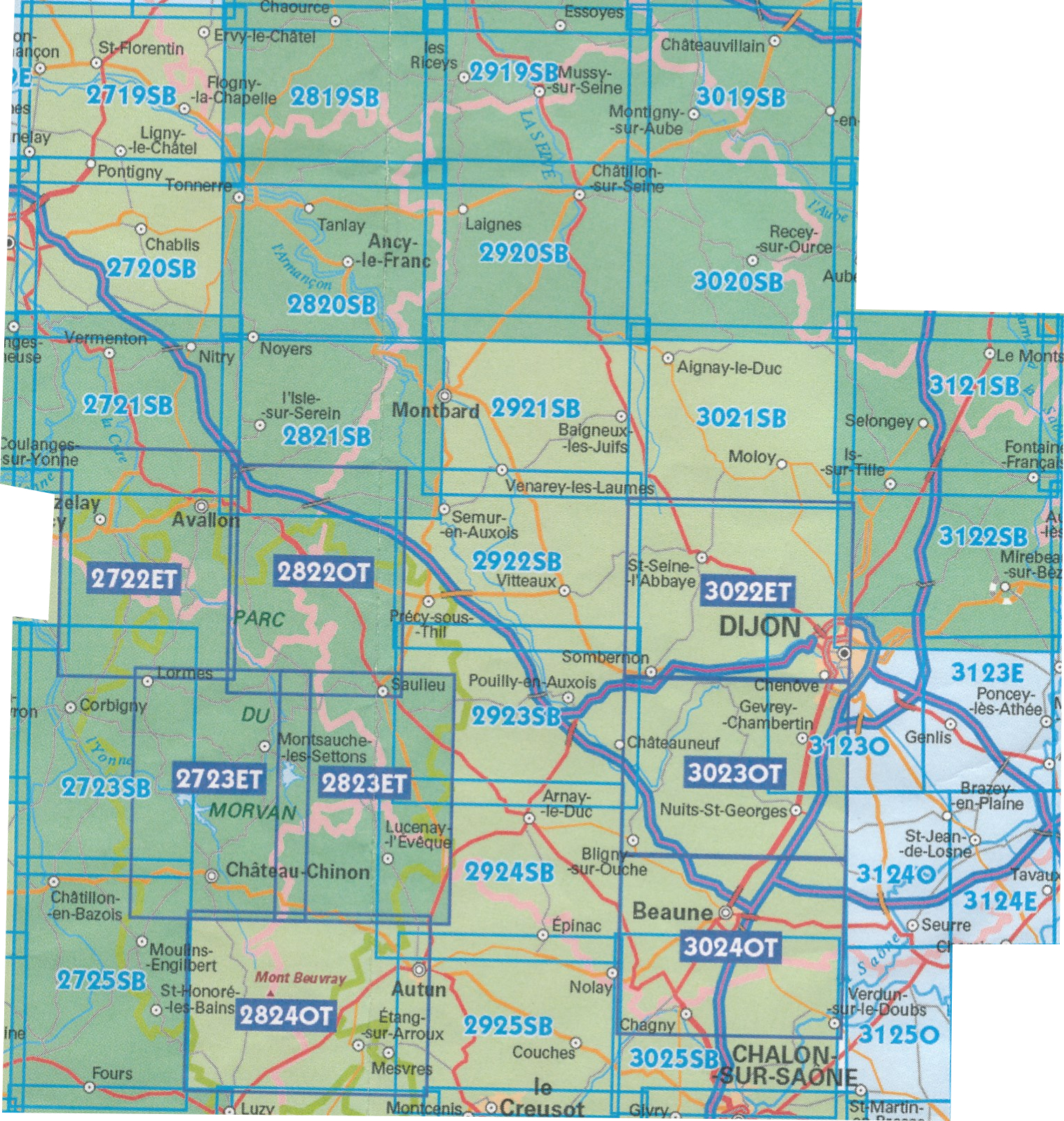
Producten op deze overzichtskaart:
Klik op een product om naar de pagina van dat product te gaan.
- Wandelkaart - Topografische kaart 2719SB Saint-Florentin – Flogny-la-Chapelle | IGN - Institut Géographique National
- Wandelkaart - Topografische kaart 2720SB Chablis, Champs-sur-Yonne | IGN - Institut Géographique National
- Topografische kaart - Wandelkaart 2721SB Vermenton | IGN - Institut Géographique National
- Topografische kaart - Wandelkaart 2722ET Avallon - Vézelay | IGN - Institut Géographique National
- Topografische kaart - Wandelkaart 2723ET Château-Chinon | IGN - Institut Géographique National
- Wandelkaart - Topografische kaart 2723SB Corbigny | IGN - Institut Géographique National
- Topografische kaart - Wandelkaart 2725SB Moulins-Engilbert | IGN - Institut Géographique National
- Topografische kaart - Wandelkaart 2819SB Chaource | IGN - Institut Géographique National
- Topografische kaart - Wandelkaart 2820SB Tonnerre | IGN - Institut Géographique National
- Topografische kaart - Wandelkaart 2821SB L'Isle-sur-Serein | IGN - Institut Géographique National
- Wandelkaart - Topografische kaart 2822OT Quarre-les-Tombes | IGN - Institut Géographique National
- Topografische kaart - Wandelkaart 2823ET Saulieu - Lac de Settons | IGN - Institut Géographique National
- Wandelkaart - Topografische kaart 2824OT Autun - Mont Beuvray | IGN - Institut Géographique National
- Topografische kaart - Wandelkaart 2919SB les Riceys | IGN - Institut Géographique National
- Topografische kaart - Wandelkaart 2920SB Châtillon-sur-Seine | IGN - Institut Géographique National
- Topografische kaart - Wandelkaart 2921SB Baigneux-les-Juifs, Alésia, Montbard | IGN - Institut Géographique National
- Wandelkaart - Topografische kaart 2922SB Semur-en-Auxois – Vitteaux | IGN - Institut Géographique National
- Wandelkaart - Topografische kaart 2923SB Pouilly-en-Auxois – Thoisy-la-Berchère | IGN - Institut Géographique National
- Wandelkaart - Topografische kaart 2924SB Arnay-le-Duc – Epignac | IGN - Institut Géographique National
- Wandelkaart - Topografische kaart 2925SB Autun - Le Creusot | IGN - Institut Géographique National
- Topografische kaart - Wandelkaart 3019SB Châteauvillain | IGN - Institut Géographique National
- Topografische kaart - Wandelkaart 3020SB Recey-sur-Ource | IGN - Institut Géographique National
- Wandelkaart - Topografische kaart 3021SB Grancey-le-Château-Neuvelle – Aignay-le-Duc | IGN - Institut Géographique National
- Wandelkaart - Topografische kaart 3022ET Val-Suzon - St-Seine-l'Abbaye - Dijon Ouest | IGN - Institut Géographique National
- Wandelkaart - Topografische kaart 3023OT Nuits-St-Georges | IGN - Institut Géographique National
- Wandelkaart - Topografische kaart 3024OT Beaune Chagny | IGN - Institut Géographique National
- Wandelkaart - Topografische kaart 3025SB Chalon-sur-Saone (Nord), Chagny | IGN - Institut Géographique National
- Topografische kaart - Wandelkaart 3121SB Is-sur-Tille | IGN - Institut Géographique National
- Wandelkaart - Topografische kaart 3122SB Mirebeau-sur-Bèze | IGN - Institut Géographique National
- Wandelkaart - Topografische kaart 3123SB Dijon | IGN - Institut Géographique National
- Wandelkaart - Topografische kaart 3124SB Seurre | IGN - Institut Géographique National
-
Topografische kaarten IGN 25.000 Bourgondië: West
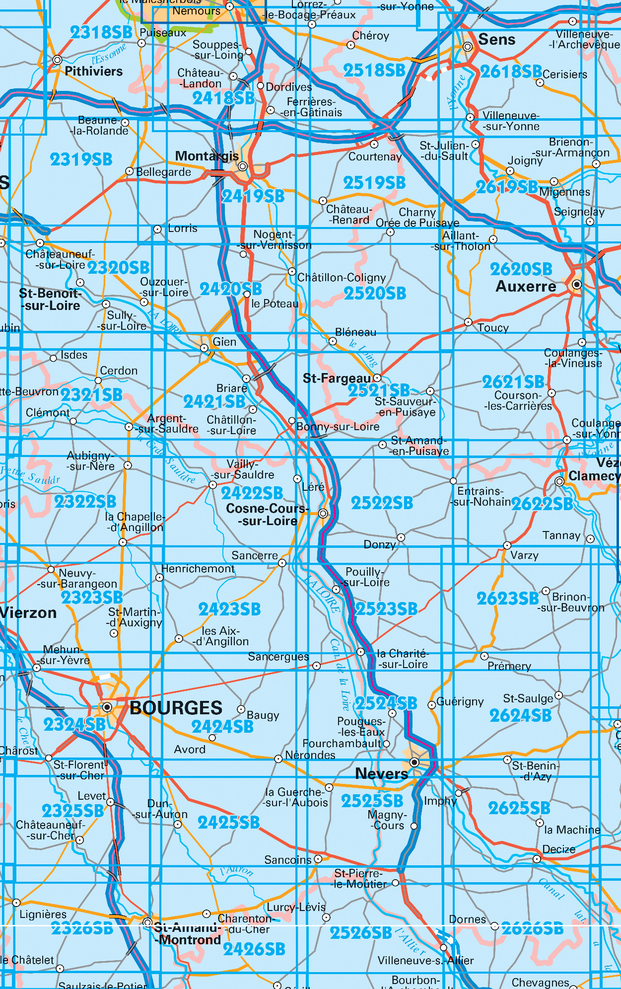
Producten op deze overzichtskaart:
Klik op een product om naar de pagina van dat product te gaan.
- Wandelkaart - Topografische kaart 2325SB Châteuneuf-sur-Cher, Levet | IGN - Institut Géographique National
- Topografische kaart - Wandelkaart 2326SB Saint-Amand-Montrond | IGN - Institut Géographique National
- Wandelkaart - Topografische kaart 2419SB Montargis - Lorris | IGN - Institut Géographique National
- Wandelkaart - Topografische kaart 2420SB Châtillon-Coligny, Nogent-sur-Vernisson | IGN - Institut Géographique National
- Wandelkaart - Topografische kaart 2421SB Briare | IGN - Institut Géographique National
- Wandelkaart - Topografische kaart 2422SB St-Satur, Léré, Vailly-sur-Sauldre | IGN - Institut Géographique National
- Wandelkaart - Topografische kaart 2423SB Les Aix-d'Angillon - Sancerre | IGN - Institut Géographique National
- Wandelkaart - Topografische kaart 2424SB Nérondes - Avord | IGN - Institut Géographique National
- Wandelkaart - Topografische kaart 2425SB Dun-sur-Aubron - Blet | IGN - Institut Géographique National
- Topografische kaart - Wandelkaart 2426SB Charenton-du-Cher | IGN - Institut Géographique National
- Wandelkaart - Topografische kaart 2519SB Courtenay, Château-Renard | IGN - Institut Géographique National
- Wandelkaart - Topografische kaart 2520SB Champignelles, Bléneau, Charny Orée de Puisaye | IGN - Institut Géographique National
- Wandelkaart - Topografische kaart 2521SB St-Fargeau, Neuvy-sur-Loire | IGN - Institut Géographique National
- Wandelkaart 2522SB Cosne-Cours-sur-Loire - Donzy | IGN
- Topografische kaart - Wandelkaart 2523SB La Charité-sur-Loire | IGN - Institut Géographique National
- Wandelkaart - Topografische kaart 2524SB Nevers, Jouet-sur-l'Aubois | IGN - Institut Géographique National
- Wandelkaart - Topografische kaart 2525SB La Guerche-sur-l'Aubois, Sancoins, Magny-Cours | IGN - Institut Géographique National
- Topografische kaart - Wandelkaart 2526SB Lurcy-Lévis | IGN - Institut Géographique National
- Wandelkaart - Topografische kaart 2618SB Sens | IGN - Institut Géographique National
- Wandelkaart - Topografische kaart 2619SB Joigny | IGN - Institut Géographique National
- Wandelkaart - Topografische kaart 2620SB Auxerre - Toucy | IGN - Institut Géographique National
- Topografische kaart - Wandelkaart 2621SB Courson-les-Carrières, Thury | IGN - Institut Géographique National
- Wandelkaart - Topografische kaart 2622SB Clamecy - Varzy | IGN - Institut Géographique National
- Topografische kaart - Wandelkaart 2623SB Prémery | IGN - Institut Géographique National
- Wandelkaart - Topografische kaart 2624SB St-Benin-D'Azy – St-Saulge | IGN - Institut Géographique National
- Wandelkaart - Topografische kaart 2625SB Decize - Imphy | IGN - Institut Géographique National
- Wandelkaart - Topografische kaart 2626SB Dornes | IGN - Institut Géographique National
Geen producten gevonden.
Laatste reviews

Zeer tevreden over mijn aankoop
Ik ben zeer tevreden over mijn aankoop. Ik heb de kaarten elke dag van de vakantie gebruikt en ze waren voor mij duidelijk en waardevol. …
★★★★★ door Jeanne Melters 30 april 2024 | Heeft dit artikel gekocht
Al met al een belangrijke aanschaf.
De kaart was bijzonder goed en zeer gedetaildeerd. Wij hebben er als wandelaars veel plezier van gehad. Ook met het rijden was de kaart , …
★★★★★ door Albert Abbink 30 april 2024 | Heeft dit artikel gekocht
Alles perfect
Snel en goed geleverd Klopt precies zoals vermeld op site 👍👍
★★★★★ door Jan Schreutelkamp 30 april 2024 | Heeft dit artikel gekocht
informatieve wandelgids
Fijne gids met leuke wandelingen. Afstanden en hoogten zijn niet nauwkeurig. Je kunt er gerust wat kilometers en hoogtemeters bijtellen.
★★★★★ door wijnand 30 april 2024 | Heeft dit artikel gekocht