Categorieën
-
Boeken
- Aanwijswoordenboeken
- Accommodatiegidsen
- Atlassen
- Bed and Breakfast Gidsen
- Bergsporthandboeken
- Campergidsen
- Camperhandboeken
- Campinggidsen
- Duikgidsen
- Fietsatlassen
- Fietsgidsen
- Fotoboeken
- Historische Atlassen
- Kanogidsen
- Kinderatlassen
- Kinderreisgidsen
- Kleurboeken
- Klimgids - Klettersteiggidsen
- Klimgids - Klimtopo
- Kookboeken
- Mountainbikegidsen
- Natuurgidsen
- Pelgrimsroutes
- Reisboeken
- Reisdagboeken
- Reisfotografiegidsen
- Reisgidsen
- Reishandboeken
- Reisinspiratieboeken
- Reisverhalen
- Sneeuwschoenwandelgidsen
- Survivalgidsen
- Tourskigidsen
- Treinreisgidsen
- Vaargidsen
- Vogelgidsen
-
Wandelgidsen
- Afrika
- Azië
-
Europa
- Albanië
- Andorra
- Armenië
- België
- Bosnië - Hercegovina
- Bulgarije
- Cyprus
- Denemarken
- Duitsland
- Engeland
- Estland
- Faroer
- Finland
- Frankrijk
- Georgië
- Griekenland
- Groenland
- Hongarije
- IJsland
- Ierland
- Italië
- Kosovo
- Kroatië
- Letland
- Liechtenstein
- Litouwen
- Luxemburg
- Malta
- Montenegro
- Nederland
- Noord-Ierland
- Noord-Macedonië
- Noorwegen
- Oostenrijk
- Polen
- Portugal
- Roemenië
- Scandinavië
-
Schotland
- Schotse Hooglanden & Speyside
- ♦ North Coast 500 | NC500
- ♦ Cairngorms National Park
- ♦ Loch Lomond & Trossach National Park
- Orkney Eilanden
- Shetlands | Shetlandeilanden
- Hebriden
- Ben Nevis - Glen Coe - Fort William
- Binnen-Hebriden
- Isle of Skye
- Arran
- Loch Ness en de Great Glen
- Lowlands | Schotse Laaglanden en grenzen
- ♦ Galloway Forest Park
- Aberdeen
- Edinburgh
- Glasgow
- 🥾 West Highland Way
- Servië
- Slovenië
- Slowakije
- Spanje
- Tsjechië
- Turkije
- Zweden
- Zwitserland
- Midden-Amerika
- Midden-Oosten
- Noord-Amerika
- Oceanië
- Wereld
- Zuid-Amerika
- Watersport handboeken
- Werken en wonen in buitenland
- Woordenboeken & Taalgidsen
- Kaarten
- Opruiming
- Puzzels
- Travel Gadgets
- Wandkaarten
- Wereldbollen
Veilig online betalen
Betaal veilig via uw eigen bankomgeving
- U bent hier:
- Home
- Europa
- Schotland
- Schotse Hooglanden & Speyside
- Boeken
- Wandelgidsen
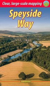
Wandelgids The Speyside Way | Rucksack Readers (9781898481997)
Buckie to Aviemore
- ISBN / CODE: 9781898481997
- Editie: 28-07-2021
- Druk: 3
- Aantal blz.: 80
- Schaal: 1:100000
- Auteur(s): Jacquetta Megarry Sandra Bardwell
- Uitgever: Rucksack Readers
- Soort: Wandelgids
- Taal: Engels
- Hoogte: 22.0 cm
- Breedte: 13.0 cm
- Gewicht: 195.0 g
- Bindwijze: Paperback
- Uitvoering: Scheur- en watervast
- Schrijf als eerste een review
-
€ 22,50
Op voorraad. Binnen 2 - 3 werkdagen in huis in Belgie Levertijd Nederland Voor 17.00 uur op werkdagen besteld, morgen in huis in Nederland Levertijd Belgie
Gratis verzending in Nederland vanaf €35,-
- Afbeeldingen
- Extra Info
- Inkijkexemplaar
Beschrijving
Deze gids een goede beschrijving van de lange afstands route. De kaarten zijn schetsmatig maar wel duidelijk.
- the Way step-by-step, with summaries of distance, terrain and refreshments
- other walks including the Badenoch Way and Dufftown circuit
- habitats and wildlife, including dolphin, osprey and wildcat
- expanded coverage of whisky-making and distilleries
- planning information for travel by car, train, bus or plane
- in full colour, with 70 photographs
- drop-down map showing the Speyside Way, plus Tomintoul spur (1:100,000)
- rucksack-friendly and on rainproof paper.
Reviews
Geen reviews gevonden voor dit product.
Schrijf een review
Graag horen wij wat u van dit artikel vindt. Vindt u het goed, leuk, mooi, slecht, lelijk, onbruikbaar of erg handig: schrijf gerust alles op! Het is niet alleen leuk om te doen maar u informeert andere klanten er ook nog mee!
Ook interessant voor europa/schotland/overig-noord
-

Wandelkaart - Topografische kaart 42
€ 19,50Topografische kaarten Schotse Hooglanden & Speyside -

Wandelgids Southern Highlands | Pock
€ 10,95Wandelgidsen Schotse Hooglanden & Speyside -

Wandelkaart - Topografische kaart 04
€ 19,50Topografische kaarten Schotse Hooglanden & Speyside -

Wandelkaart - Topografische kaart 01
€ 19,50Topografische kaarten Schotse Hooglanden & Speyside -

Wandelkaart - Topografische kaart 43
€ 19,50Topografische kaarten Schotse Hooglanden & Speyside


