Categorieën
Veilig online betalen
Betaal veilig via uw eigen bankomgeving
Wandkaart Spanje, 70 x 50 cm | CNIG - Instituto Geográfico Nacional (9788441637160)
Papieren versie
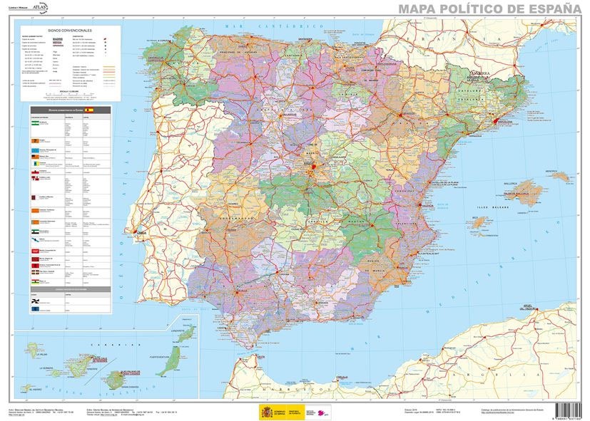
- ISBN / CODE: 9788441637160
- Schaal: 1:2250000
- Uitgever: CNIG - Instituto Geográfico Nacional
- Soort: Wandkaart van een land
- Taal: Spaans
- Hoogte: 50.0 cm
- Breedte: 70.0 cm
- Uitvoering: Papier
- Bindwijze: -
- Schrijf als eerste een review
-
€ 16,95
Op voorraad. Voor 17.00 uur op werkdagen besteld, morgen in huis in Nederland Levertijd Belgie
Gratis verzending in Nederland vanaf €35,-

Beschrijving
Next to the map is a panel listing Spain’s autonomous regions, including Ceuta and Melilla, each with its flag, plus a list of its constituent provinces and their capitals.
Mapa General de España (Península Ibérica, Baleares, Canarias, Ceuta, Melilla y posesiones españolas en el norte de África) a escala 1:2.000.000, con división autonómica. Proyección Lambert.
Reviews
Geen reviews gevonden voor dit product.
Schrijf een review
Graag horen wij wat u van dit artikel vindt. Vindt u het goed, leuk, mooi, slecht, lelijk, onbruikbaar of erg handig: schrijf gerust alles op! Het is niet alleen leuk om te doen maar u informeert andere klanten er ook nog mee!
Ook interessant voor europa/spanje
-

Campergids Met de Camper door Spanje
€ 18,95Campergidsen Spanje -

Wegenkaart - landkaart Spanje | Borc
€ 11,50Wegenkaarten Spanje -

Reisverhaal Typisch Spanje | Frieda
€ 18,50Reisverhalen Spanje -

Reisgids National Geographic Spanje
€ 27,99Reisgidsen Spanje -

Woordenboek Wat & Hoe taalgids Spaan
€ 10,99Woordenboeken & Taalgidsen Spanje