Categorieën
Veilig online betalen
Betaal veilig via uw eigen bankomgeving
Wandkaarten van landen
Wandkaart van de wereld kopen? Laat uw interieur de grenzen verleggen met onze collectie landkaarten
Heeft u een speciale band met een bepaald land of vindt u de vorm van Groot-Brittannië gewoon erg mooi bij uw interieur staan? Er zijn landkaarten van veel verschillende landen: van Alaska tot Australië. De meeste zijn zeer gedetailleerd en geven steden, wateren, bergruggen en grenzen aan, sommige geven slechts lijnen en kunt u zelf inkleuren.
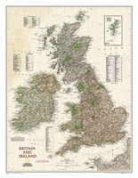 Wandkaart 20442 Groot Brittannië en Ierland antiek, 60 x 76 cm | National Geographic
This map of Britain and Ireland shows country boundaries, thousands of place names, major roadways, airports, bodies of water, and more. Rich earth-toned colors, astounding detail and boardroom quality make …
★★★★★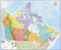 Wandkaart Canada, 120 x 100 cm | Maps International
Mooi, heldere wandkaart van Canada. This Canada wall map clearly depicts all the cities, major roads and also shows all the Provinces and Territory boundaries. All major cities and …
★★★★★★★★★★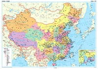 Wandkaart China – political, 95 x 69 cm | Gizi Map
Een wandkaart van China waarop de politieke grenzen en steden tweetalig staan weergeven. Natuurkundige aspecten zijn weggelaten, maar dat komt de politieke en bestuurlijke indeling duidelijk ten goede. Afmetingen: 69cm.x …
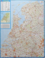 Wandkaart 34 Nederland Basic, 100 x 130 cm | Falk
Wandkaart - Falk Nederland met een formaat van 130 (h) X 100 (b) cm. Het is een zeer gedetailleerde en duidelijke wandkaart, met veel plaatsen, wegen met wegnummers, afritten. Deze …
★★★★★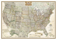 Wandkaart 20114 USA - Verenigde Staten politiek, antiek, 108 x 75 cm | National Geographic
Wandkaart van de USA waarbij de kleuren in 'antieke' look zijn weergegeven, de staatgrenzen zeer duidelijk zijn en er veel plaatsen op staan. This Antique-style USA Wall Map by National …
★★★★★★★★★★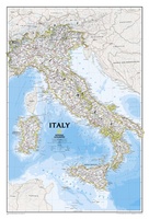 Wandkaart Italy – Italië, 59 x 87 cm | National Geographic
Decoratieve wandkaart van Italië. Naast de mooie kleuren staan er bijzonder veel plaatsen op vermeld. This Italy Wall Map by National Geographic contains extensive political information with political boundaries clearly …
★★★★★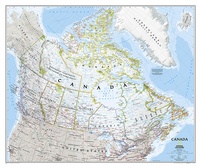 Wandkaart 20527 Canada, 97 x 82 cm | National Geographic
Decoratieve wandkaart van Canada. Naast de mooie kleuren staan er bijzonder veel plaatsen op vermeld. This beautiful wall-map from National Geographic depicts Canada and the areas surrounding the Great Lakes …
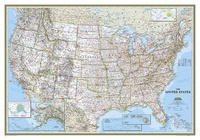 Wandkaart 02003 USA - Verenigde Staten Political, 110 x 77 cm | National Geographic
Het klassieke kaartbeeld van National Geographic, de grenzen van de staten van Amerika zijn apart gekleurd. De wandkaart is heel gedetailleerd met veel plaatsen, wegen, rivieren en nationale parken, het …
★★★★★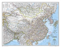 Wandkaart 20057 China, 76 x 59 cm | National Geographic
Decoratieve wandkaart van China. Naast de mooie kleuren staan er bijzonder veel plaatsen op vermeld. Het gaat soms een beetje ten kosten van de schoonheid van de kaart, maar daardoor …
★★★★★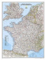 Wandkaart 22074 Frankrijk, België en Nederland, 60 x 77 cm | National Geographic
>Our classic wall map of France, Belgium, and the Netherlands shows political boundaries, major highways and roads, cities and towns, and a wealth of other incredibly accurate geographic detail. …
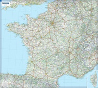 Wandkaart Frankrijk – France, 111 x 100 cm | Michelin
Dubbelzijdig geplastificeerde wandkaart van de klassieke overzichtskaart van Michelin Frankrijk. Als altijd zeer overzichtelijk en voorzien van een mooie heldere kleurstelling. Prachtig aan de muur! Op deze kaart is het wegennet identiek …
★★★★★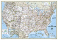 Wandkaart 02008 USA - Verenigde Staten Political, 178 x 124 cm | National Geographic
Het klassieke kaartbeeld van National Geographic, de grenzen van de staten van Amerika zijn apart gekleurd. De wandkaart is heel gedetailleerd met veel plaatsen, wegen, rivieren en nationale parken, het …
★★★★★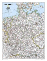 Wandkaart 02814 Germany – Duitsland, 58 x 76 cm | National Geographic
Decoratieve wandkaart van Duitsland. Naast de mooie kleuren staan er bijzonder veel plaatsen op vermeld. National Geographic's political map of Germany includes everything from country boundaries, major roads, towns …
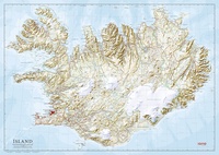 Wandkaart IJsland 158 x 112 cm | Ferdakort
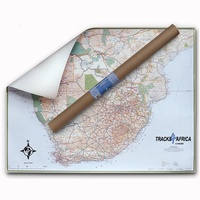 Wandkaart Southern -Africa - Afrika Zuidelijk | 130 x 98 cm | Tracks4Africa
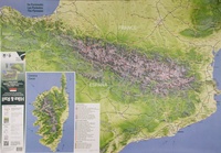 Wandkaart Hike and Rail Alpen Pyreneeën Corsica | Alta Via
 Wandkaart Das Grosse Alpen - panorama, sommer / zomer uitgave | 202 x 60,6 cm | MairDumont
Wandkaart van de hele Alpen van oost naar west met de namen van de bergtoppen. Mooie uitvoering om in details alle valleien en bergruggen te zien. De mogelijkheden om te …
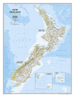 Wandkaart New Zealand - Nieuw Zeeland 60 x 77 cm | National Geographic
Mooie heldere wandkaart van Nieuw Zeeland met het Noordereiland en Zuidereiland op dezelfde kant afgebeeld. Veel plaatsnamen, goed kleurgebruik waardoor hoogteverschillen en bijvoorbeeld nationale parken goed zichtbaar zijn. The …
★★★★★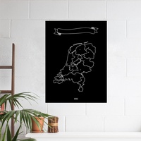 Wandkaart Krijtbord Nederland Woody Map Chalkboard | Miss Wood
Naast de bekende Woody Map prikborden komt het Spaanse merk Miss Wood nu met een zwarte met krijt beschrijfbare kleeffolie waarop Nederland staat afgebeeld. Er worden 6 krijtjes in verschillende …
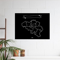 Opruiming - Wandkaart Krijtbord België Woody Map Chalkboard | Miss Wood
Naast de bekende Woody Map prikborden komt het Spaanse merk Miss Wood nu met een zwarte met krijt beschrijfbare kleeffolie waarop België staat afgebeeld. Er worden 6 krijtjes in verschillende …
★★★★★
- 1
- 2
- 3
- Volgende >>
- 5
Waar moet je op letten als je een goede wandkaart van een land wilt kopen?
Welke verschillende soorten wandkaarten van landen zijn er eigenlijk: het kaartbeeld?
Verschillende projecties, hoe zit een wandkaart er uit?
Zijn er wandkaarten van alle landen beschikbaar?
Het formaat van een wandkaart van een land
De leesbaarheid van een wandkaart van een land
Veel uitvoeringen van dezelfde wandkaart van een land
Hoe wordt de wandkaart verzonden?
Laatste reviews

Kan de huidige ontstuimige ontwikkelingen wereldwijd, nu ook geografisch plaatsen en daarmee beter volgen.
★★★★★ door Leo Janssen 20 december 2024 | Heeft dit artikel gekocht
We hadden Piëmonte al eens bezocht en voor onze komende reis werd ons door kennissen deze gids aanbevolen. Inderdaad is dit een heel goede gids. …
★★★★★ door DWKdB 19 december 2024 | Heeft dit artikel gekocht
Mijn bestellingen zijn altijd goed en worden altijd op tijd geleverd. Komen afspraken goed na. Erg tevreden.
★★★★★ door Ben Wegdam 19 december 2024 | Heeft dit artikel gekocht
Zeer gedetailleerde kaart van het zuidelijke deel van het douaniers pad
★★★★★ door Marian 18 december 2024 | Heeft dit artikel gekocht