Categorieën
Veilig online betalen
Betaal veilig via uw eigen bankomgeving
National Geographic
Dit bekende tv-kanaal heeft naast prachtige natuurdocumontaires en magazines ook zijn eigen reisgidsen en wegenkaarten uitgegeven. De landkaarten zijn gedrukt op scheurvast en waterbestendig papier wat een vergrootte levensduur betekent. De kaarten zijn helder en bevatten een schat aan informatie voor zowel de 'gewone' toerist als de avonturier. De hoofdwegen zijn duidelijk aangegeven, maar ook de secundaire wegen en tracks staan er op. Met de nationale parken duidelijk en mooie zwemplekken of attracties aangegeven onderscheidt deze kaartenserie zich van de andere wegenkaarten. De kaarten heten dan ook niet voor niets Adventure Maps! Het avontuur wacht!
 Wandkaart Europa, politiek & antiek, 249 x 194 cm | National Geographic
Deze kaart wordt gemaakt in drie delen - te groot om in 1 keer te fabriceren met kans op beschadigingen - die vervolgens zeer nauwkeurig aan elkaar worden geplakt. …
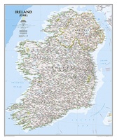 Wandkaart Ireland – Ierland, 76 x 91 cm | National Geographic
National Geographic Maps' new Ireland wall map is one of the most authoritative maps yet published of the Emerald Isle. Of the nearly 1,000 place-names shown on this map, all …
★★★★★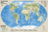 Wereldkaart Dynamic earth plate tectonics, 92 x 61 cm | National Geographic
The new Dynamic Earth wall map illustrates plate tectonics and features new bathymetry and naturally colored relief, as well as current volcano and earthquake data. Notable earthquakes and eruptions lists …
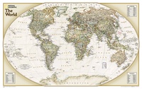 Wereldkaart Politiek & antiek, 82 x 51 cm | National Geographic
The World Explorer Executive uses the Winkel-Tripel Map Projection, which strikes the best balance of accuracy, aesthetics, and proportion, eliminating the issue found in many other maps where Greenland appears …
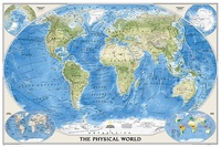 Wereldkaart Natuurkundig, oceaanbodem, 116 x 77 cm | National Geographic
Bijzonder fraaie natuurkundige kaart van National Geographic waarbij het accent ligt op de fysische aspecten van de aarde met veel details van de oceanen. Een schoonheid aan de muur! …
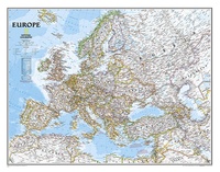 Wandkaart Europa, politiek, 114 x 88 cm | National Geographic
This colorful Europe political map clearly shows country boundaries, capitals, many major cities, bodies of water, airports, major highways and roads, and much more.
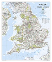
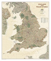 Wandkaart Engeland en Wales, antiek, 76 x 91 cm | National Geographic
This earth-toned, executive-style map of England and Wales shows political boundaries, major highways and roads, cities and towns, airports, and other geographic details. Thousands of place-names and exact borders are …
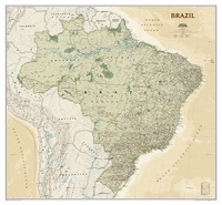 Wandkaart Brazil - Brazillië Antiek, 104 x 97 cm | National Geographic
Presented in National Geographic’s classic wall map style, our large, earth-tone Brazil wall map is ideal for home or office. Inherent to all National Geographic reference cartography, this map contains …
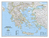 Wandkaart Greece – Griekenland, 77 x 60 cm | National Geographic
Decoratieve wandkaart van Griekenland. Naast de mooie kleuren staan er bijzonder veel plaatsen op vermeld. The classic National Geographic wall map of Greece shows this beautiful area in uncompromisingly …
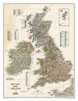 Wandkaart Britain and Ireland - Groot Brittannië en Ierland antiek, 60 x 76 cm | National Geographic
This map of Britain and Ireland shows country boundaries, thousands of place names, major roadways, airports, bodies of water, and more. Rich earth-toned colors, astounding detail and boardroom quality make …
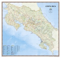 Wandkaart Costa Rica, 97 x 92 cm | National Geographic
Decoratieve wandkaart van Costa Rica. Naast de mooie kleuren staan er bijzonder veel plaatsen op vermeld. This full-color map is a richly detailed rendering of one of Central America's …
★★★★★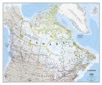 Wandkaart Canada, 97 x 82 cm | National Geographic
Decoratieve wandkaart van Canada. Naast de mooie kleuren staan er bijzonder veel plaatsen op vermeld. This beautiful wall-map from National Geographic depicts Canada and the areas surrounding the Great …
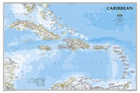 Wandkaart Caribbean – Caraïben, 91 x 61 cm | National Geographic
Completely redesigned and updated, National Geographic Maps' Caribbean Classic wall map is one of the most authoritative maps for the islands of the Caribbean Sea. This new edition shows the …
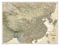 Wandkaart China, antiek, 76 x 59 cm | National Geographic
This detailed political map of China accurately shows locations of provincial boundaries, cities and towns, major highways and roads, rivers and waterways, and other geographic features.
 Wandkaart Engeland en Wales, 76 x 92 cm | National Geographic
This classic-style map of England and Wales shows political boundaries, major highways and roads, cities and towns, airports, and other geographic details. Thousands of place-names and exact borders are carefully …
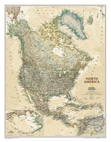 Wandkaart Noord Amerika, politiek & antiek, 60 x 78 cm | National Geographic
This richly colored map of North America - featuring country boundaries, place names, major highways and roads, and bodies of water - is excellent for reference in your home or …
 Wandkaart Canada, 97 x 82 cm | National Geographic
Decoratieve wandkaart van Canada. Naast de mooie kleuren staan er bijzonder veel plaatsen op vermeld. This beautiful wall-map from National Geographic depicts Canada and the areas surrounding the Great Lakes …
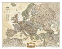 Wandkaart Europa, politiek & antiek, 116 x 90 cm | National Geographic
National Geographic is a renowned authority in cartography. For 120 years the Society's maps have helped spread geographic knowledge around the globe. A vast database allows National Geographic to combine …
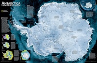 Wandkaart Antarctica Satellite Map, 78 x 50 cm | National Geographic
This digital mosaic of 4,500 satellite scans shows incredible detail of Antarctica's terrain. Includes insets that show the surface elevation, ice sheet thickness, ice flow velocity, and sea ice movement …
★★★★★
Laatste reviews

Veel kaarten op stock en gemakkelijk te bestellen. Snel geleverd
★★★★★ door Rob 29 april 2024 | Heeft dit artikel gekocht
We hebben een landkaart van Albanië besteld. Deze hebben we in goede staat ontvangen
★★★★★ door Ida van der Heiden 26 april 2024 | Heeft dit artikel gekocht
Zoals gewend van de Alpverein weer een mooie en duidelijke kaart voor dit mooie wandelgebied incl. hutten.
★★★★★ door B van R 26 april 2024 | Heeft dit artikel gekocht
Duidelijke en mooie kaart van het gebied. Oogt stevig/dik waardoor niet snel kapot tijdens wandelingen. Sommige tekens zijn wel wat aan de kleine kant waardoor …
★★★★★ door B van R 26 april 2024 | Heeft dit artikel gekocht