Categorieën
Veilig online betalen
Betaal veilig via uw eigen bankomgeving
Wandkaarten - Engeland
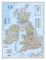 Wandkaart Britain and Ireland - Groot Brittannië en Ierland, 60 x 76 cm | National Geographic
This classic-style map of England and Wales shows political boundaries, major highways and roads, cities and towns, airports, and other geographic details. Thousands of place-names and exact borders are carefully …
 Stadskaart London City Skyline – Londen, 84 x 59 cm | Maps International
Een schitterende en kleurrijke aquarel van de skyline van Londen. Een aanwinst voor elke muur. A bright and colourful watercolour skyline of the city of London. With bold, dynamic …
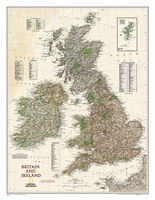 Wandkaart Groot Brittannië en Ierland antiek, 60 x 76 cm | National Geographic
This map of Britain and Ireland shows country boundaries, thousands of place names, major roadways, airports, bodies of water, and more. Rich earth-toned colors, astounding detail and boardroom quality make …
★★★★★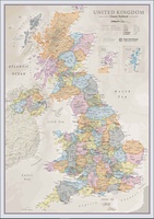 Wandkaart Classic Verenigd Koninkrijk | UK | Great Brittain | 85 x 60 cm | Maps International
Ontdek de rijke historie en schilderachtige landschappen van het Verenigd Koninkrijk met onze prachtige wandkaart, vormgegeven in een elegante klassieke stijl. Deze gedetailleerde kaart toont niet alleen de verschillende landen …
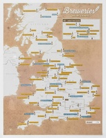 Scratch Map Bier Brouwerijen Groot-Brittannië Collect & Scratch | Maps International
Scratch Off UK Breweries Print is the perfect gift for beer lovers. This is the best way to display your travels to each brewery or if you have sampled the …
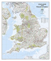 Wandkaart Engeland en Wales, 76 x 92 cm | National Geographic
This classic-style map of England and Wales shows political boundaries, major highways and roads, cities and towns, airports, and other geographic details. Thousands of place-names and exact borders are carefully …
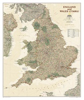 Wandkaart Engeland en Wales, antiek, 76 x 91 cm | National Geographic
This earth-toned, executive-style map of England and Wales shows political boundaries, major highways and roads, cities and towns, airports, and other geographic details. Thousands of place-names and exact borders are …
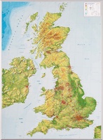 Reliëfkaart Great Britain & Ireland - Groot Brittannië & Ierland | GeoRelief
De uitgever van de kaart is de bekende Duitse uitgever GeoRelief. Deze topografische kaart van Groot Brittannië heeft een hoge kwaliteit met prachtige kleuren. De kaart bevat de namen van …
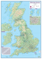 Wandkaart Engeland - British Isles roadplanning wall map, 84 X 119 cm | Maps International
Routeplanner map from Maps International's selection of British Isles maps. Routeplanning map details: British Isles routeplanning map shows the motorways, major roads and transport hubs such as airports and …
Laatste reviews

We hebben een landkaart van Albanië besteld. Deze hebben we in goede staat ontvangen
★★★★★ door Ida van der Heiden 26 april 2024 | Heeft dit artikel gekocht
Zoals gewend van de Alpverein weer een mooie en duidelijke kaart voor dit mooie wandelgebied incl. hutten.
★★★★★ door B van R 26 april 2024 | Heeft dit artikel gekocht
Duidelijke en mooie kaart van het gebied. Oogt stevig/dik waardoor niet snel kapot tijdens wandelingen. Sommige tekens zijn wel wat aan de kleine kant waardoor …
★★★★★ door B van R 26 april 2024 | Heeft dit artikel gekocht
Voor een reis Ivoorkust is er weiniginformatie te vinden. Dit boek brengt het meeste. Duidelijk en overzichtelijk.
★★★★★ door Annemiek van Riezen 26 april 2024 | Heeft dit artikel gekocht